
During the Great Hunger, families evicted from lowland farms took refuge on Slieve Gullion, occupying old booley huts or building simple cabins, clearing heather and bracken to grow food on the thin acid soil. When the forestry was felled on the south-western slopes we found the ruins of their homes.
THE LAST MOUNTAIN COMMUNITY
The townland of Slievegullion is a thousand-acre slice of mountainside that runs up to the Cailleach Beara’s Lake and has a tiny fringe of poor, rocky farmland along its southern edge, bounded by Dromintee, Cloughinnea and Longfield townlands.  It is not mentioned on the Hearth Tax Rolls of 1665, which presumably means it was uninhabited. Nobody lives there now. We might never have known anybody did, except for the Mountain Drive that cuts across it.
1834 Ordnance Survey map

 In the census of 1821 there were five families totalling 22 people registered as living there. Until 1836 land-holders of all religions had to pay tithes, a tax for the upkeep of the Church of Ireland and its ministers. The title list for 1828 showed 12 landholders, most not living in the townland. Spelling was a bit wobbly so a bit of guesswork is needed to compare the lists. I’d love to know how the McShanes got away without paying tithes.

On the 1834 Ordnance Survey map the townland appears to have contained seven or eight substantial dwellings, a few cabins which may or may not have been inhabited and a scatter of old roofless booley huts. There were a few little enclosed fields around the houses; the dotted markings on the map indicate that even the enclosed areas had not been cleared of heather or scrub.
By 1864 there were 27 landholding families on the Griffiths Valuation list with a combined annual valuation of £123 and 5 shillings. They were all tenants of Arthur Hughes, a middleman from Longfield House who held 770 acres, mostly mountainside, from the main landlord, A.J. Reid. While settlement was still mainly on the southern edge, the houses and enclosed fields now extended up beyond the 300-meter contour.
The settled part of the townland is made up of two glens: according to the late Dr McAteer they were once known as Gleann na gCúac (Glen of the Cuckoo) to the east and Gleann na Smól (Glen of the Thrush) to the west. Gleann na gCúac, which is now skirted for its whole length by the Mountain Drive, was the older settlement.
Five families lived in this eastern glen along the rough road up from Dromintee that deteriorated to a rough track towards the high mountain reaches.


The McShanes dominated the glen, holding more land than the other four families combined.


John Mulholland lived in the highest cottage, at an altitude of 318 metres above sea level (for reference, the summit is at 576 meters, the Three Steps pub at 100 meters). The house is still there, close to the mountain drive just before it turns sharply down towards Dromintee. In living memory Paddy and Kitty Haggan (O’Hagan) lived there.

Although the ground is tough and stony in Gleann na gCúach, it may well have had some pockets of tillage farming in the past. The western glen is an altogether different proposition: steep, rocky mountainside falling away towards Longfield. A rough track leads in from Gleann na gCuach and down towards the Longfield road (green line). This was upgraded a bit by the Forestry Service which seems to have used rubble from at least one dwelling house for retaining walls for the road. The two Conroy households had a lane connecting out to the track (red line) and there was even an attempt at fancy piers at the entrance.


But beyond that there is no sign of any kind of track leading in to six more houses. The houses in Gleann na Smólach were small; some had only one room. In their current state of repair it is hard to see if they all had chimneys, possibly not.

Although we know from the census that most of the houses were inhabited well into the 20th century, a lot of them have collapsed, indicating that they were not very well built in the first place. Only a couple of the lower ones have any signs of slates or corrugated roofing: they may have been thatched with oat straw but some were more likely roofed with scraws, thick topsods of heather roots which can make a relatively short-lived but quite watertight roof.
There is little sign of systematic attempts to clear the land except for little patches, little more than gardens close to the ruined houses where they probably grew potatoes for own consumption. There are a few low ditches but no real field pattern comparable with the eastern glen. Most of the land is too rough, the soil too thin and probably too acidic for any kind of tillage, but there is barely even much evidence of consistent grazing given the extent of heather cover. The fact is that this was a fairly hopeless place to try any sort of farming, even rough cattle farming.
Ground like that needs to be cleared by steady burning and it needs huge amounts of lime and manure but it would still never be really productive, even for decent grass. There is simply no way the people who lived here could have been living off this land. 
All around Slieve Gullion the landscape tells a story of steady encroachment on the mountain in the mid-nineteenth century as an expanding population sought to reclaim land by clearing bracken, rocks and heather. Comparison of the limits of agricultural land in 1834 and 1864 tells a powerful story of the ladder farms creeping up the hillsides (green = 1834, red = 1864).
What happened in Gleann na Smól must have been different. There is nothing steady or systematic about what happened here. This place can only have been settled by people who were absolutely desperate, and that means homeless people, that means people who had been evicted from better land down below. Like evicted people all over Ireland, they headed up the mountain to where the old booley huts used to be. These huts were really bits of low circular walls or more likely just heaps of stones, but they turned them into crude shelters and gradually improved them into cabins and in the fullness of time some of them turned into two-room cottages. They built them in sheltered spots, in dips and folds in the landscape, so much part of that landscape that their ruins can now be hard to find.
North-west of the two glens, cut off from them and only accessible via a network of lanes from the Longfield road, there was a tiny pocket of farmed land within Slieve Gullion townland in 1 864. None of this steep mountainside had been cleared nor were there any dwellings here in 1834.

In holding no. 5 – Margaret Magee (later spelt McGee) – the ruins of a substantial house with sheds can be found tight against the Mountain Drive road. It has an unusual but once common architectural feature in its open-fronted chimney flue. The front and chimney breast would have been made from sally woven into wickerwork and plastered inside and out with clay.
200 metres down the steep road, near the old exit for Longfield, there are ruins of a house which is not marked on the 19th century maps, which means it must be much older and was already a ruin in the 1830s.
Although we can’t find any trace of a track between this enclave and the lower glens, it seems that love does indeed conquer all, even rough ground. In 1861 James McGee (holding No.5) married Bridget Grogan (holding No. 22) in Dromintee chapel.
 In Gleann na Smól itself there were 15 families in 1864 where there had only been four in 1834, trying to scratch a living, but how they did it is a mystery.
In the bottom corner of holding no. 12 (Patrick McCourt) there are ruins of an older dwelling and outhouses. Again it is not marked on the 19th century maps which suggests it was already a ruin and not worth marking even as an animal shelter. Much the same applies to a rather more intriguing ruin 300 meters due west in the woods on holding no.9 (Reid).

There are four walls of a strong and well-built house with a good chimney stack and plenty of evidence that it was slated. The intriguing aspect is that it has a very substantial high stone wall all around, far beyond what would have been needed to keep animals either in or out, giving it an almost fort-like appearance.
The purpose of the Griffiths Valuation, a 20-year project, was to establish a base line for charging rates to finance the Poor Law and local government. Just like today, values were based on a theoretical notion of the likely rent that a house might attract. In Gleann na gCúach the substantial McShane farm buildings were valued at £1 a year, but in Gleann na Smól most of the houses were valued at the minimum 5 shillings.
The land there was typically valued at 5 shillings an acre and in some cases less. By way of comparison, below in Longfield there was no land valued under 10 shillings an acre and most of it was valued between 15 shillings and £1. Houses in Longfield were mostly valued above £1 and some were considerably higher. Arthur Hughes, the middleman landlord of the mountain, had a house valued at £14 a year that must have been visible from the mountain hovels he was taking rent out of.
In the 1901 census for the townland  (Slievegullion) the number of households is almost unchanged and some of the earlier families are still there but there are plenty of new names, presumably due more to intermarriage than a desire to live up there with a good view. ( House numbers for 1901 and 1911 have no relation to each other or to landholding numbers from 1864.)
In the house furthest in from the lane, five members of the Boyle family were at home on census night. The enumerator, John Stewart, must have been a bit sloppy because Boyle turned into Bayle on the main list and the Kegans turned into Hegans. He also failed to record whether the Boyles spoke Irish: the parents John and Rose almost certainly did but there was a trend at the time, often encouraged by the clergy, to prevent the children of the house picking it up. It may or may not be relevant that, according to the Hannaway family, he was actually Constable Stewart of the RIC. Rose was a McShane from Gleann na GCúach. Owen frequently headed off for seasonal agricultural work in England and Scotland.


The younger Owen Boyle, aged 10, was listed under Occupation as ‘Scholar’. That meant a walk of nearly four miles to the school in Dromintee, as the last family up there – the Flanagans – were still doing in the 1950s. Young Owen was unlikely to be taking that long walk much longer, for at 10 years of age he was ready for the Fair Green in Forkill. There were three others in the Boyle family – Patrick, Annie and Susan aged 14 – who had already gone to the Green. If we want to understand anything about life in these glens and how people survived, we must understand the role of the Hiring Fair, what Michael J. Murphy – or Mickey Buck as we knew him – called the slave market.

In the 19th century the rent on the land had to be paid in two instalments a year on the Gale Days at the beginning of May and November. Just before the Gale Days fairs were held in Forkhill, Crossmaglen and Camlough and until the 1860s in Cullyhanna and Jonesborough as well. There was a lively trade in animals to raise the rent and there was also a thriving market in child labour. Young people would line up with their possessions in a bundle to be poked and prodded by farmers and questioned about their farm-work skills. Then a price would be agreed with their father and a small deposit paid.
,Michael J. Murphy’s mother was hired as a farm labourer at the age of 10, as was my own grandmother, Bridget McNally of Adavoyle.. Granny only went as far as the Oul Road in Dromintee where she was employed cleaning out stable and byre for a family that didn’t own a wheelbarrow. She did it using a wire potato basket. Michael J.’s mother was hired for the princely sum of thirty shillings for six months. They weren’t wage-earners but indentured servants, which meant that even the few protections in 19th century labour law didn’t apply to them. If they left a farmer before the six months was up they lost all the money. Many of them had to sleep in barns and outhouses, they were mainly fed spuds and porridge, and young girls were particularly vulnerable. The youngest children were hired locally but after a year or two they would be sent for better money “down the country” which was Dromintee short-hand for big Protestant farms north of Newry. “Away down the country” meant north of Banbridge. Hiring fairs were abolished by the Free State government in the 1920s but persisted in the north until 1942.
 Patrick Boyle went off to war in 1914, and got wounded. Younger brother Owen followed suit. Sadly, he didn’t come back.
The Boyles were all literate in 1901 and Owen senior could sign the return form himself. Not so his neighbour John Kegan who signed with his x-mark witnessed by the enumerator.  Out of 24 heads of household, only six could sign with their own name. It is sad to think that there had been a national school in Dromintee since 1860 when the older householders would have been of school age.

The House and Building Return specifies that the Boyle house was thatched, had two rooms and, interestingly, was owned by them. Most tenants acquired their land from the Wyndham Land Act of 1903: this land must have been freed under one of the earlier acts. The Out-offices return specified that they had a cowhouse, fowl house, piggery and barn. If so, they have all since been swallowed by the mountain. There is just one miserable calf house which is really a partly walled-off shelter under an overhanging rock.
In fact, the whole Out-offices Return for the townland seems to be an extraordinary work of fiction with its two stables, ten byres, 11 piggeries and eight barns. Where have they gone? Only the main McShane farm in lower Gleann na gCúac and the outlying McGee dwelling mentioned above boasted anything resembling a farmyard.
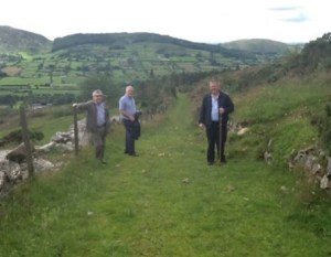 The Boyles only appear on the 1911 census as landowners: the house was probably abandoned. But they came back to it and Annie and Katie (Catherine on the 1901 census) spent their final years there. For this information we have to thank the McCormack brothers of Dromintee – Mick, Gerry and John – pictured here on the track leading from Gleann na gCúach towards Gleann na Smól and the Boyle house.
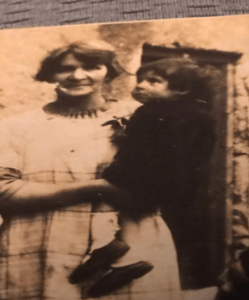
  Susan Boyle, missing as a 14-year-old from the 1901 count, was their grandmother, shown with her sister Katie and at the house with a child.

Five houses in the townland had slate roofs; with one exception the houses on the Gleann na Smól side were all thatched. The three single-roomed houses were also on that side, with five members of the McMahon family in one of them; no house in the townland had more than two rooms.
In the little enclave to the north-west, nine members of the McGee family lived in a two-room thatched cottage with two windows.
That’s not the whole story. There had actually been more McGees in that little house – three had gone to the hiring fair and were absent on census night. Bridget aged 14 was a domestic servant in Banbridge; James aged 16 was a farm hand with the Acheson family in Mountnorris; and Patrick aged 18 was a farm hand in Glenn on the other side of Newry. Young John joined up and was wounded in Flanders in 1916 and killed in action in Thessalonika in July 1917.
Catherine, then aged 10, eventually got married in Govan, Glasgow in 1923. Her father James was dead but her mother Mary attended – Mary’s maiden name was Boyle; she was a daughter of Patrick Boyle who had been the tenant in holding no. 13 on the Griffiths list in 1864. Bridget and her two sons are listed on the passenger manifest for the SS Caledonia which departed Glasgow on 29th May 1926 heading for New York.
Mr Stewart the enumerator found 85 people in Slievegullion townland on the night in question – Sunday 31st March 1901. Some of the abstract pages are missing but it seems they were all Roman Catholics. He only filled in the “Language” column for five households indicating that the parents spoke Irish. In nearby Cloghinnea a more meticulous enumerator, Philip McGettigan, was finding adult Irish speakers in virtually every house.

 By 1911 there were just 55 people in the townland on census night and the number of households was down to 13, with four previous occupiers – Conroy, Loughran, McConville and O’Neill – listed as landowners only. The single-roomed cabins were now uninhabited but there were still nine McGees in two rooms. This area we live in never ceases to amaze me. It seems this particular bit of the mighty McGee clan was known as the “Hangin’ Dresser McGees”.
Any of you who walk this bit of land, particularly on the Gleann na Smól side, are bound to ask yourselves: “What in the name of God did these people live on?” As noted, it clearly wasn’t the land. Animals would survive but could not thrive in anything like the sort of numbers needed to support 85 human beings in 1901. Some men no doubt went to the hiring fair but no hired farm hand could get the sort of money that a grown man needed to support a family, not with a constant stream of cheap boys and girls coming on to the market every year. The majority of adult men in the glen must have taken off every year for the tatie-hokin in Scotland or the wheat harvest in the east of England.
So what else did they live on. We could ask the same question of most of South Armagh, which has been vastly overpopulated in relation to land quality since the Plantation of Ulster pushed people into the high rocky places. Evolution seems to have produced some special quality of survival which found an outlet in curious forms of commerce. In evidence to the Devon Commission in the 1840s witnesses told of hawkers with backpacks full of what were then exotic fruits going door to door on the mountain roads around Slieve Gullion. From the cadgers of Omeath to the dalin’ men from Crossmaglen and the Pahvees of Dromintee and Killeavy, the people that Mickey Buck proudly called the Mountainy Men found ever new ways to turn a shilling. None were stranger than the Goat Men.

The first picture shows Irish goats for sale in the market square in Dorking in Surrey around 1890. The second shows men and boys with a herd of Irish goats on a road in Wiltshire a couple of years earlier.

According to the leading authority on the Old Irish Goat, many tens of thousands of milking goats were sold off in the slums of England in the reign of Victoria and the trade was totally dominated by Dromintee men. Several times a year, men from Connemara and Mayo drove great herds to the  fair in Forkhill for sale. I like to think that that fella with the widebrimmed hat might just be Cornelius Murphy, my great great grand-uncle, because this was his stock in trade.
The only inhabitants of Slieve Gullion townland today are those same Old Irish Goats. Were they herded and rested there before heading on the long road to Dorking? Did a few escape on to the mountain? Did a few lads from Gleann na Smól help drive them, or as we say here cap them, all the way to Wiltshire?
In 1901, a number of people in the townland were aged 60 or over. Apart from mortality, there is another reason they might have left the mountain glens by 1911. In 1908, Chancellor of the Exchequer David Lloyd George introduced the first Old Age Pension at the princely sum of five shillings a week for those aged 70 or over. Given the level of poverty that there clearly was in the townland, a regular if paltry income may well have made housing in the lowlands more feasible. If you are tracing relatives through the census you need a bit of a health warning. Supposing you find your great granny was 73 in 1911: in your naivety you might expect that on the 1901 census she would be around, let’s say 63. What you may find is that she was only 58. It could be a mistake but it could also be that since no one born before 1863 had a birth certificate, she suddenly put on five years in 1908. Without comment as to the causes, I offer you a selection of elderly people in Slieve Gullion at the time:
Bernard McShane – age 60 in 1901, 72 in 1911: James McShane – age 57 in 1901, 71 in 1911
Mary Healy – aged 55 in 1901, 71 in 1911: James McGee – aged 55 in 1901, 71 in 1911
Michael McGee – aged 60 in 1901, 78 in 1911
You could, however, be called in front of a Pension Board to prove your age or demonstrate eligibility. Now we have all heard of the Night of the Big Wind. It happened on 6th January 1839, the Feast of the Epiphany, when a massive hurricane hit Ireland, killing hundreds and wrecking up to a fifth of the houses in some areas. But the real reason we have heard of it is that in 1908 the word went around like lightning: “The Pension Board will ask you what you remember from the Night of the Big Wind.”
Not everything had changed by 1911: there were still nine Hangin Dresser McGees in one two-roomed cabin, and seven McParlands in another one, and of the occupied houses only three had slated roofs. Again, all were listed as Roman Catholics. Enumerator John Cunningham was also a bit slapdash about the “Language” column but we know that at least half of the households had Irish speakers. Interestingly, there seems to have been good progress on the literacy front since 1901 because only four heads of household made their x-mark on the form. Some of the signatures, which are a bit shaky looking, were by people who had made a mark in 1901.
 So when did people leave this last mountain community? I remember when people came down from Gleann na gCúach and the lower Mountain Road, and why. It began in the mid-1950s and continued through the 1960s as social housing became available in Dromintee. Presumably the same thing was happening on the other side with movement into Forkhill, but the quality of housing was so very poor in Gleann na Smólach that I suspect it was abandoned much earlier.
For those who would like to lead walks into Gleann na Smólach and visit these houses, warn your walkers that it is a tough trek. All the green area shown in the map was planted by the Forestry Service in the 1970s and most of the trees around the houses were felled more than ten years ago, which is when we found them. The big problem for walking is that they left behind a lot of forestry debris which is now greasy small logs and hidden beneath the grass and it’s pretty lethal in the wet.

I began leading walks in here and documenting the houses about six or seven years ago. Since then I have brought in several teams of volunteers to clear paths, but the impact is limited and it all needs doing again. But it can be done and it should be done because we have something pretty unique here and I don’t think we have uncovered all the houses yet. Specifically, I have not investigated the Griffiths Valuation holdings no. 21 (Grogan) and 22 (Lear) in the extreme south of the townland where the 1864 map indicates substantial buildings. I would like to think that the coming generations around Slieve Gullion will know something of the courage and determination and sheer survival skills of our Last Mountain Community. How can we leave this legacy to them? The first step might be to secure a commitment from the Forestry Service that the house ruins will be protected: this cannot be taken for granted as contractors have wiped out a ring fort on Daikilmore and put bulldozers through the Famine walls on Slieve Gullion.
Imagine if we could get a simple storyboard on a strong fencepost in front of each house, with an A4-sized facsimile of the 1901 census return for the house printed on it in some robust and lasting material.