
We are the land of the cow, we are the people of the cow. There are 8.5 million cattle on the island of Ireland, which is 1.3 per head of human population: our near neighbours in England have to do with just one cow between about ten of them. Our language and culture are full of cows: the amount of cow detail in the Brehon Laws really is incredible. Cows made us.

If you Google Slieve Gullion or go into the Ring of Gullion website, this is the sort of thing that jumps out at you: the chequerboard vista of stone walls and ditches and hedges. Sometimes this is called an ancient landscape, which it certainly is not. I want to disentangle all that by looking at the landscape and trying to interpret it. Sometimes the best way to understand the big picture is to focus on one element, in this case one that doesn’t feature in our history despite being a massive part of our past – booleying.
 There are hundreds of booley sites in the Ring of Gullion and Cooley, but we will focus on two which
 are easily accessible and little more than a kilometre apart, in the townlands of Ballintemple and Ballard.

Booleys were summer grazing areas in the mountains where people herded cattle, living in crude stone huts which were rebuilt and re-roofed every spring.
This structure on the 330-meter contour line in Ballintemple is about 2 km due north from the Courtyard. It is exceptionally large – too large to be an ordinary booley hut. It is almost certainly a Famine-era rebuild: some desperate family, evicted from the lowlands, came up the mountain and constructed a temporary refuge using stones from a number of booley huts – and we know there were plenty here.
 On the surrounding hillsides are the tell-tale signs: green patches in the heather from centuries of
 manure where the cattle were herded; bits of walls or heaps of stones, remains of the booley huts; and nearby, the stream was a source of pure water for churning and making butter. On the Ballard site a stream comes off the higher slopes of Slieve Gullion and flows past the ruined booley huts, heading for the Camlough River. On the Ballintemple site the extensive Brown Bog drains through the booley area into a fast stream, one of the headwaters of the Flurry River.
These sites and booley huts were occupied from early May until mid-August or early September. Cattle were generally taken to booley within their own townland; the animals that grazed here came from the area around Killeavy Old Church and Murray’s Corner. But when we look down at that area today, we don’t see the landscape that the cattle and the people came from, we don’t see what they saw.

 In the late 18th century when booleying was at its height, there was no chequerboard of rectangular fields, there was no line of white farmhouses and cottages. In historical terms all those stone ditches and hedges are new; most are only about 200 years old; virtually none were there 300 years ago. We have to re-imagine open grazing land instead, with small herds of cattle constantly herded by men and boys, and an awful lot of bog.
The houses didn’t stretch out in a line along the road; they were built in  loose clusters five or ten together, each known as a baile. Around them there was limited growing of crops behind temporary fences of thorn bushes and wattle hurdles. The 1834 Ordnance Survey map of Cloghinnea clearly shows the clustering. Even when fields were enclosed on the orders of the landlords, people still preferred to live in the clusters which persisted well into the 20th century and can still be seen in “oul’ walls”. Somehow the notion that Irish people always lived on individual isolated farms, one family per farm, has taken hold in the history books, but it is nonsense. This is how we lived – in rural clusters and extended families working the land together – and the evidence is all around us. This is how we lived when we first occupied the 40,000 or so ringforts scattered across the country a couple of thousand years ago.
The main crop protection was provided by the herders who kept the cattle out of the corn. Herding was a full-time activity for a large proportion of the population, especially the young. But in the main growing season the cattle were gone along with the boys and girls and almost all the older women, to the mountains or bogs, to the booleys.
All around Slieve Gullion, all these ditches we can see were built on the orders of landlords, all in a couple of generations from about 1760 onwards. The landlords wanted “one man one farm”, and they wanted to maximise rents by encouraging more tillage farming for cash crops in enclosed fields. First, they had to put an end to the old methods of arable farming on open fields known as rundale, where varying qualities of land were divided among a group of families, the origin of the cooperative working teams we know as meitheal. Then they had to get people to build endless miles of ditches, usually without compensation. This forced enclosure, known as “the squaring of the ditches”, led to endless disputes between tenants and with landlords and their agents, and some believe it was at the root of the shooting of Meredith Chambre in 1852.
To understand how booleying worked, we have to understand the long interaction between cattle farming, tillage farming and the landscape of Ireland.
This is the land of the cow: we have 8.5 million cattle on this island, which gives us 1.3 head of cattle apiece. Our near neighbours in England have to share each of their cows between more than 10 people. A thousand years ago when there were only perhaps half a million people in the country there may well have been several million cattle. When I was young and used to accompany my father to the mart in Camlough they would let bullocks into the holding pen beside the sale ring ten at a time. He used to say: “You see them ten bullocks? We can only eat one of them in this country- the rest have to go on the boat. And if they don’t go on the boat, you’ll be on the boat.” That was probably always true in a general way: we produced far more beef than we can consume.
 We are the people of the cow. In the Céide Fields in Mayo there are miles of stone walls deep under the turf, built by cattle farmers five and a half thousand years ago. We are more cow-dependent than ever because a vast – and almost certainly unwise – expansion of our dairy herd since abolition of EU quotas means we can consume a far smaller proportion of our milk products. Six out of every ten bullocks end up in English supermarkets: now we are dependent on markets in China, West Africa and the Caribbeann to place our milk powder.
Sheep are a relative novelty in Ireland: we have never had large-scale wool production like England. Sheep were introduced by the Normans and were generally restricted to the English-dominated Pale until their rapid expansion in the 20th century, largely in response to an ill-advised EU headage payment system.

Five to six thousand years ago Neolithic farmers engaged in tillage farming, as we can see from the many hundreds of turf-covered cultivation ridges at Doolargy in Cooley. But tillage has always been secondary to beef and dairy cattle farming. The high points of tillage were probably the early 14th century and the decades before the Great Famine when population pressures forced the cultivation of every spare corner for food. There were rises again in the two world wars and into the 1950s in response to government incentives. But by and large Ireland has gone back to what we did well on our rainy island for millennia, what we used to call dog-and-stick farming. Newgrange and the cairn on Slieve Gullion were built with the profits from cattle farming, which was the dominant form of agriculture then, as it still is today.
Our great epic story of 2000 years ago, the Táin Bó Cúailgne, is not really about a queen who went to war because she coveted her  neighbour’s bull, but rather about winning and holding power in a society where cows were the currency
 and unit of value, the glue that held society together. The Táin refers to the Gap of the North as Bearnas Bó Uladh – roughly, the cattle-raiding Pass of Ulster.
Every February when I was a lad, the first St Brigid’s cross had to be  hung above the byre door, to protect the cows and the milk; that was just a faint echo of invoking the protection of Bríd, the fertility goddess of the sun-worshippers and bull-worshippers, with her classic sun-wheel symbol that the Christians turned into an extremely odd cross. With the protection of Bríd the sun shone, the grass grew, the cattle put on beef and the bull ensured a bigger herd next year.
In ancient Ireland you could buy a slave-woman for just six cows. Crimes were paid for in cows, up to and including murder, and because they were legal tender there is a quite extraordinary amount of detail in the Brehon Laws on how to measure and value them. The centrality of cattle is reflected in all sorts of aspects of our ancient and medieval culture. Our word for a boy – búachaill – originally meant cowherd, for in early Irish society pretty much everyone was a cowherd. A road was a cow track – bóthar – which Brehon Law prescribed should be wide enough for a cow to stand crossways on it with enough room for another cow and her calf to pass by. Gaelic society operate its own kind of feudal system based more on cattle transactions and grazing rights than land ownership. Much warfare revolved around cattle raids and even more warfare was certainly averted by handing over cattle. Our first celebrity high king, Brian Ború, got his title from the cattle taxes he exacted from petty kingdoms; “pay me some of your cows or I’ll come and take the lot.”
The Anglo-Normans who arrived in the late 1100s from Northern France and England were used to tillage farming and they were mainly interested in Leinster and parts of Munster best suited to tillage. For our ancestors in the rest of the country agriculture remained overwhelmingly pastoral; tillage was a secondary, supplementary activity. Wealth and political power was measured not in acres, but in great herds of cattle, so your wealth could move around. You didn’t need to own the land, just for your cattle to have access to it and use of it. The Normans made hay to carry to their cattle in the winter, the Irish drove their cattle to the grass – and unlike many other countries there was grass all year: we could winter our cattle out.
In this difference there was a culture clash which has never been truly resolved. Tillage means you need a guarantee that the land you tilled in the spring will still be in your possession at harvest time. Fencing, liming, manuring all require even longer perspectives, even greater certainty of possession, even greater guarantees from mighty men. For the Irish sort of mainly pastoral agriculture you didn’t need to defend a particular bit of land to the death – you could always move, with your wealth of cows and plant a little crop elsewhere. In extremities you could go to the bog or the mountain and wait for better times. Boundaries of all kinds were more theoretical than real and always open to adjustment, by discussion or by force. Such fluid boundaries did not require a permanent, top-down feudal hierarchy to impose and maintain them.
The pollen record shows that tillage farming reached a high point around 1300 as the Anglo-Norman colony in Leinster reached maximum power, before it was knocked off course by the Bruce invasion and then the Black Death. Tillage reached another high point in the generations before the Famine as every garden or bit of waste ground was used for potatoes to feed what may have been nearly 9 million people. This was the point at which our landscape changed, at which the ditches were built.


On John Rocque’s map of 1760 it is clear that there is no direct route from Dromintee to Jonesborough, no Finnegans Road. You could either go by the Old Road and Moyra castle (red), or via Barrawully to the Molly Road(yellow). Either way, although the map is crude, it is clear you were skirting great areas of bog. It is not hard to work out where the bogs were, if we mark the areas under the 100-meter contour on a modern map. Large parts of Adavoyle, Faughiletra and Faughilotra townlands were bogland. There is still a patch of bogland in the middle of each of these marked areas, but this was no wasteland. The bogs were relatively dry and there was plenty of grazing in them. In fact, in Ireland as a whole there was probably more booleying in the bogs than in the mountains. But an ever-expanding population needed turf for fuel.


The first Ordnance Survey map in 1834 shows Finnegan’s road and all its rather straight side roads in place. As far as we know this road was built in the years 1818-22. A later map shows the way the road cut diagonally through the ditches, leaving a series of triangular fields known as the ‘Farls of Bread’. This tells us that this whole area was drained and a layer of turf taken off for fuel, creating new cutaway land which was enclosed into fields, between 1760 and 1820. The same process was happening around Longfield, Meigh, Cloghogue and Killean. You can still tell when you are driving through cutaway because the road is often higher than the fields, running on top of the old turf layer. When I was a child the Adavoyle road was lowered for about 800 meters by the removal of turf up to three meters deep. The same process lowered Finnegans Road through Dromintee bog.
So how did this all work before 1750 or so, when there was fairly open countryside? To understand that you need to learn a couple of new terms or concepts, and the first one is meitheal.
 When I was a young lad people still came together for major events in the farming calendar, but particularly for threshing corn. When certain neighbours turned up carrying their pitchforks, my father would say: “There, that’s the meitheal.” It wasn’t random neighbourliness, in fact often these men were not immediate neighbours. There was no obvious plan or system, but Paddy this and Mickey that always came to our mill and we always went to theirs. We were part of an acknowledged network of mutual obligations. In fact, the meitheal we knew was the last echo of a complicated system of not just working together, but of living in small groups and owning or at least holding land in small groups,known as rundale.
When we look at the 1864 Griffiths Valuation maps for the Ring of Gullion we see lots of divided holdings. This is the area adjacent to the modern housing estate in Dromintee: 
It can be tricky linking up 47a and 47b, or 46a, b, c and d with the names on the list of tenants of the Jones estate; holdings 48a, b and c are strung out over a quarter of a mile, separated by a couple of other farms. The ditches had all been built but the farms had not in fact been squared into compact holdings. These split and scattered farm holdings were the relics of rundale.
In earlier forms, rundale meant that it was the group or cluster of families that had the relationship with the landlord, whether formalised in a lease or not.
Some historians believe that 60 percent of Mayo was still in rundale at the time of the Griffiths Valuation. It was certainly alive and well in Omeath in 1857, where the Fourth Earl of  Anglesea let the whole townland of Ardaghy – 443 acres – to just four groups of tenants. Holding no. 3 comprising 127 acres was held by a group of 15 families who lived in a tight housing cluster which is still there today. Their little strips of tillage and grazing radiate out from the cluster, separated by mearings which were often just a line of sods or stones. Around the whole lot was a ditch and beyond that was open grazing. This is what ancient, medieval and early modern Ireland looked like. But where and when did it start?

In the townland of Carrickasticken there are eight ringforts marked on the modern map as raths. Built about 1500-2000 years ago, each of these simple earth and stone banks formed a sort of corral that protected cattle herds from night-time raiders with two legs or four. Within each ringfort was a cluster of little houses: around it were a few enclosed fields for crops of oats, barley, greens and root vegetables. Each household had its strips of each crop within the field and the crops were rotated within the fields every few years to avoid exhausting the soil, with some fields lying fallow or going back to grazing. With each rotation and crop change it was often necessary to redistribute strips within each field. These were the infields; beyond were the outfields where the grazing cattle were herded and milked. Further away were the mountain grazing and turf plots.
 Fast-forward amore than a thousand years; there were potatoes in the crop strips but little else had changed. In rundale the unit of agricultural production was not the single-family farm but a group typically of 10 but perhaps 20 or more families who may have held land from a landlord but paid for it and controlled it as a group. And as a group they divided the land among themselves for various productive purposes, regularly redistributing it to ensure crop rotation and best practice, for example to avoid overgrazing. It was not so much about working together – it was every man for himself planting and harvesting his own corn strip and potato strip – as co-ordination, ensuring all the corn was planted at the same time and that grazing cows did not wander into the crop strips.
Behind their little houses was the open mountain for rough grazing: in front was their arable ground, their three big infields for tillage, and below the outfield for good grazing. When they worked the infields, that was the original meitheal in action, the co-ordinated system of working that was needed to make rundale work. It was not occasional but permanent, and it was not voluntary. It was not really communal since it only covered a specific and limited group of families. James Connolly reckoned it was a bit socialistic but that is a hard argument to sustain; Karl Marx was less impressed. It was not at all egalitarian: redistribution which often took place every three years or so left everyone with more or less the same amount of land but adjusted for its productive quality. The families regularly elected a chief, often called An Taoiseach, who negotiated with the landlord or his agent, collected the rent and adjudicated on disputes, which by all accounts were frequent. However imperfect, there was a degree of social control over the land and its productive capacity no matter who formally owned it.
When the bogs of Adavoyle and Ayallogue and Faughilotra and Longfield were drained and cut away, when heather and bracken was cleared on the mountainside in Clonlum or Annahaia or Ballard or Cloghinnea, that work was done by the meitheal teams from the rundale clusters. But the new land was not added to the rundale holdings, it was enclosed into the ‘ladder farms’ we see running up the hills. These were let more and more on the ‘one man, one farm’ system. Yet long after the enclosure, long after their cattle were grazing in the different little rectangular fields, people came together at Imbolc, the beginning of May, to drive the cattle up the mountain as they had always done. For a hundred years or so, up to the huge disruption of the Famine, oneman/onefarm co-existed with the relics of rundale.
Tradition decreed that the cattle should first be driven between two bonfires, part of some ancient cleansing ritual. Then off they went, generally the old and the women and the young, carrying rafters and churns and milking stools and bedding; maybe even beehives and spinning wheels. Rafters were valuable and were carried up and down every year. The first thing they did was to reroof the huts with scraws, the topsod of the heather. Then they milked the cows and churned butter which they wrapped in the leaves of cabbage grown at the booleys. In ancient times they buried butter in peat bogs to preserve it: some bog butter finds have been dated at 3000 years old. Archaeologists from Trinity College claim to have eaten 1400-year-old butter. They said it was fine but it could have done with a bit more salt.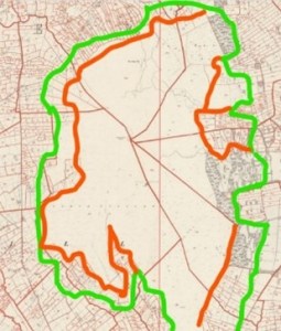
In Ballintemple and nearby Clonlum, the meaitheal gradually reclaimed the mountain right up to the 300-meter contour; only in Ballard is there higher farmland. It seems from the maps that these were late ladder farms; much of this reclamation was done after the famine. If we compare the Ordnance Survey map of 1834-36 with the Griffiths Valuation map of 1864 we can get some idea of the steady, massive encroachment as the peak population just before the Famine pushed the farmland ever higher on every side of Slieve Gullion (green line 1834, red line 1864).

Some of the cottages here were inhabited until the 1970s and 80s. Others look very much like single-room shelters from the famine era, hastily built by people evicted from farms down in the valley. In the woods nearby there is a ruined dwelling which is not marked on the 19th century maps, indicating it was already a ruin; it could well be from the 17th century or earlier.

In the Griffiths Valuation the booley area was mapped in a way which could not be done today; the small enclosures around the booleys would now be impossible to find in deep heather, so the ground must have been much more bare in the 1860s. Only some of the enclosures had earth ditches or stone walls. Most were ‘mearings’, narrow earth banks just one or two sods high designed to show boundaries.

Like rundale itself, booleying was not communal but operated on the basis of very limited group co-operation, so don’t let me catch your cow eating grass on our side of the mearing.
If we merge the Griffiths map with a Google satellite map we can see that the patches of green grass among the black heather fit well with the booley enclosures manured for centuries by the herds.
 We are lucky to have one of the few booley sites anywhere which have been professionally excavated. This diagram is from an article in the Proceedings of the Royal Irish Academy: Archaeology, Culture, History, Literature Vol. 90C (1990), pp. 123-134. It describes archaeological digs done about 30 years ago which found a layer of charcoal around the site dated to around 4000BC, indicating that Neolithic farmers used fire to clear the land. Pollen analysis of soils under stone walls indicates they were built around 2400BC. This underlines what is already known from a number of sites in Cooley: booley huts and cattle enclosures are often the recycled remains of Neolithic settlements. The area designated C contains a number of cultivation ridges which look like lazy beds; Neolithic farmers used similar beds for growing corn but pollen samples were inconclusive.
There are larger and better preserved booley sites in Cooley where the fields never climbed as high into the hills. In Omeath the main area was Tullagh Glen, the great sweep of ground running up from Tullagh Bridge towards the television mast. My friend Andrew McGuinness, who worked on the Cooley Fieldnames Project, drew me this map showing all the placenames associated with booleying. Around Omeath a booley is known as a ‘mari’ and a number are marked on the map, but there is nothing definitive from the Gaelic scholars on the origins of the term.
Many booley sites were absorbed into farmland as the ditches came up the hillside. All that encroachment was into prime booley sites. To fully understand our landscape and how it developed you need to be able to unimagine more than 90% of the ditches and three-quarters of the houses you can see every day.
Then you have to imagine a place where large numbers of people, mostly young, did nothing all day except herd, herd, herd cattle, maybe deliberately driving them slowly back and forth to make sure they manured a particular bit of ground. And imagine a place  where more than half the population abandoned their homes and took off for the mountains with the cattle for months at a time. The same upland grazing system, known as transhumance, operated in Switzerland and Austria and to a certain extent still does in Italy. The difference in the Ring of Gullion is that most people were looking down at their own houses and could walk home in an hour or so. It was quite a festive affair, like going on holiday with your cows. And they say that no matter how many young people went up the mountain, generally a few more came down.
Looking at the broad sweep of Irish history over 2000 years and pre-history stretching back three or four millennia before that , you would have to say we tried tillage farming a few times and we didn’t really like it that much. Since 1960 the acreage devoted to arable farming in the Republic has declined by nearly three-quarters. Stand high on Slieve Gullion in the spring and try to spot the ploughed fields. You won’t find many, and if you do it probably means someone is reseeding for more silage or hay. We are back to where we started thousands of years ago, to dog-and-stick farming. You get a lock of bullocks and throw them into a field and then the warm, damp wind blows in from the Atlantic 300 days a year and makes the grass grow. We should actually worship the wind.
There is a great, yawning cultural gap between tillage farming and pastoral farming. The tiller of the soil wants to stay in the one place; the pastoral farmer can move a bit and must do so if there is no grass. The tiller needs to be certain that this bit of ground where he sowed his seed in the spring will still be under his control in the autumn harvest; so he needs to own the ground. The pastoral farmer just wants access to the ground, use of the land, and if he can’t have this bit then that bit over there will do instead; ownership can be a looser concept. The tiller needs ditches and boundaries and borders, the cattle man needs none of them. For one, wealth equals land; for the other, the herd is the wealth.
Distrust of the pastoral which went to the heart of the English establishment in Ireland is evident in the writing of the Elizabethan poet Edmund Spenser, who had land in Cork: “The people that live thus in these bollies grow thereby the more barbarous and live more licentiously than they could in towns, using what means they list and practicing what mischiefs and villainies they will, either against the government there generally by their combinations, or against private men whom they malign by stealing there goods or murdering them; for their they think themselves half-exempted from law and obedience.” Earlier an English official complained: “the want of good enclosures is a great help to the rebels, who suddenly raid for cattle and drive them off.” Another official wrote that booleying was a good nursery for a thief.
A decade ago when there was short-lived talk of commemorating the Plantation of Ulster, a few unionist historians came out with the old chestnut that the Plantation was not a land-grab at all. Their theory and origin myth is that the Planters merely started farming land that was not being used – well, apart from a few fellas with sticks and dogs running around chasing cattle. Like the Normans, they wrote the history of their invasion in terms of wilderness, but there is no wilderness in Ireland and there has been none for 6000 years. Even on the highest mountain we can see the impact of humankind, and far more importantly, the impact of cattle.
However, we have not studied the social or cultural significance of booleying. There is a theory circulating now among ethno-archaeologists that the summer pasture in Ireland and elsewhere in northern Europe was more of a female domain than the home farm, a place of special social and sexual freedom for the youth in general but young women in particular – you go off to summer camp but you have to bring the cows.
In Ireland our Nobel prizes are not in maths or physics, and in the arts we have always been behind the curve producing painters and sculptors. We are the people of the word – spoken and written, just as much as we are the people of the cow. There is a well-founded theory that booleying was crucial in the development and maintenance of a strong oral tradition and transmission of oral culture through the generations. The booley was a special place where the very old and the very young socialised together day after day and night after night. At night when the milking was done and the herd safely settled, what else was there do but tell stories and sing songs around the fire?
This is where we came from. This is who we are.